

Looking at a map of the Columbia Valley, you can’t help but notice the expansive network of trails that spider across the vast terrain. For many locals in the Columbia Valley, exploring valley bottoms, over mountain passes and across alpine meadows have become more than just a pastime. Hiking provides an opportunity for individuals to interact and experience the environment in an immersive way. We have curated a collection of local trails for individuals looking to embrace nature and all its wonder.
Hiking Trails
Cobb Lake Trail
Level of Difficulty: Easy
Length: 5.4 km roundtrip
Time: 2 hours
Cobb Lake is considered a hidden gem by many of the Locals in Radium Hot Springs. Located just off of Highway 93, this trail offers gentle switchbacks down the side of the valley to Swede Creek. Here you will roam through an open forest of lodgepole pine and white spruce, and take in the pristine views of Cobb Lake and Sinclair Mountain.
Sinclair Canyon
Level of Difficulty: Easy
Length: 6 km
Time: 2 hours
This interpretive trail offers a series of stunning vistas showcasing the Village of Radium Hot Springs and the Purcell Mountains. The full loop is roughly around 12-kilometres, but with a wide variety of diverse and interconnected trails you can adjust the distance, elevation and time spent to suit the needs of your group.

Dog Lake Trail
Level of Difficulty: Easy
Length: 5.2 km roundtrip
Time: 1.5 hours
If you’re looking for an easy hike – Dog Lake trail is the trail for you! Starting at McLeod Meadows Campground the trail crosses the raging Kootenay River over two suspension bridges, then takes a forested route overlooking a scenic lake and the peaks of Mitchell range.
Paint Pots
Level of Difficulty: Easy
Length: 2 km roundtrip
Time: 40 minutes
This trail is a great way to stretch your legs. This short and sweet 2km hike takes you over the crystal-clear waters for Vermillion River through a lush forest to a meadow. Soon after you will discover interpretive signs describing the history of the First Nations who used the iron-rich ochre for body paint.
Old Coach Trail
Level of Difficulty: Easy
Length: 9km
Time: 3 hours
Winding along the Columbia River, the Old Coach Trail runs between Radium Hot Springs and Dry Gulch; offering expansive views of evergreen forests and sandstone bluffs (also known as hoodoos). Perfect for the whole family to bike or hike, it winds along with the benchlands of the Columbia River, offering picturesque views of the Columbia Valley Wetlands.
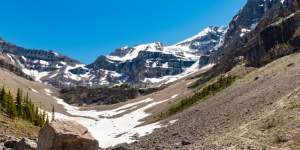
Stanley Glacier
Level of Difficulty: Moderate
Length: 9km
Time: 5-7 hours
There’s something spectacular about getting close to ancient compacted ice and snow. After you cross the Vermillion River you then switchback through the pine forest. The benefits of this hike are that you can see the glacier from almost any vantage point on the hike, but as you get closer you will spot mini-waterfalls cascading down the cliffs of the south wall. There is a fantastic spot at the top of the bluff to eat lunch and marvel in the panoramic view of mountain peaks.
Swansea Summit
Level of Difficulty: Moderate
Length: 6.23km – 14km
Time: 3-5 hours
The first trail to the summit of Mount Swansea was originally constructed to service a copper mining operation just below the summit of the mountain. There are two variations that can be on Swansea: The south ridge trail and the loop to the communications towers. The communications tower trail offers a shorter 6km round trip, while the south ridge trail is approximately 14km with a 745-meter elevation gain. The summit offers 360-degree panoramic views of the surrounding lakes, valley and mountains. If you’re lucky, you may witness a paraglider as they launch to catch the thermals from the valley below.
Lake of the Hanging Glacier
Level of Difficulty: Moderate
Length: 17.2 km
Time: 7-9 hours
If you are looking to experience a classic wilderness hike, The Lake of the Hanging Glaciers is for you. This is one of the most popular hiking trails in the area, taking you across numerous creeks, moderate switchbacks, and gradual climbs through alpine meadows before you reaching the north shore of the lake with the sharp glacier on the opposite short.

Sinclair Pass
Level of Difficulty: Difficult
Length: 17.5km
Time: 6 hours
This hike takes about 4-5 hours and features fabulous views of the local mountains, including Devil’s Tooth, Mount Sinclair and Mount Kindersley. The initial part of this trail is heavily wooded, but after 2.2km, an avalanche chute opens up the trail to a kaleidoscope of brightly coloured flowers.
Jumbo Pass
Level of Difficulty: Difficult
Hiking Time: 11km
Time: 5-7 hours
Located on the traditional territory of the Ktunaxa Nation, the Jumbo Pass trail head offers beautiful views of alpine ridges covered in larch and surrounded by peaks and glaciers. You will find that the trails are covered with a number of logs and planks to keep your feet dry and protect the fragile ecosystem. Continue on to the Jumbo Pass Cabin, which is located another 10 minutes down the trail for unapparelled views from Horseshoe Glacier to the Lieutenants and Jumbo and Karnak Mountains.
With so many ways to take in the outdoors, this region of British Columbia, no doubt, will ignite your passion for nature. We look forward to welcoming all visitors to the Columbia Valley.


Recent Comments